
在全球公用事业加速数字化的背景下,地理空间数据与人工智能的融合正在成为基础设施管理的重要变量。报告指出,公用事业的核心目标在于保障水、电、燃气与通信等关键服务的可靠交付,而高精度地理空间数据是实现资产可视化、网络优化和故障快速响应的基础。随着资产规模扩大和网络结构复杂化,传统人工与规则驱动的方法已难以满足效率与准确性的双重要求,GeoAI因此进入战略窗口期。
从市场数据看,GeoAI的成长动能十分明确。2024年全球地理空间市场规模约为5600亿美元,预计2028年将接近1万亿美元,年复合增长率达15.9%,其中公用事业板块占比约18%。中东地理空间市场预计将从2024年的11.6亿美元增长至2029年的17.1亿美元。与此同时,全球AI市场预计2030年达到1.81万亿美元,中东AI市场同期将从119亿美元跃升至1663亿美元。地理空间与AI双重高增长,构成GeoAI在公用事业落地的坚实宏观基础。
GeoAI的价值不在于简单叠加技术,而在于能力重构。传统地理空间分析侧重空间关系与可视化,AI强调预测与自动化,而GeoAI将深度学习、计算机视觉与时空数据结合,实现预测性空间模型和自动特征识别。这使得巡检、维护和规划从“事后响应”转向“事前预测”,并显著提升规模化处理能力与分析精度。
在具体应用层面,GeoAI已在多个场景验证商业价值。电力领域通过无人机影像与深度学习模型识别破损绝缘子,将原本依赖人工巡检的高成本流程转化为分钟级自动检测,显著降低运维成本。天然气管网利用卫星影像与时间序列分析,对160公里以上高压管线的地表形变进行厘米级监测,实现风险分级与精准干预。电信运营商则通过实时空间分析优化话务路由与5G部署,部署成本下降25%,移动网速提升20%。
但GeoAI并非“即插即用”。报告系统梳理了实施障碍,包括数据质量参差、异构系统整合困难、前期投资压力、AI与地理空间复合型人才短缺,以及隐私与网络安全合规要求。特别是在关键基础设施领域,模型可解释性不足和潜在偏差问题,可能直接影响运营安全与公众信任。
为降低实施风险,报告提出分阶段推进框架:从业务问题定义与战略对齐入手,评估数据与组织成熟度;通过高价值场景原型验证ROI;再逐步扩展至企业级集成,并辅以持续监控和优化。这一路径强调治理、变革管理与技术并重,避免技术先行导致的资源错配。
从趋势判断看,GeoAI正在从工具层走向操作系统层。随着数字孪生、边缘计算和生成式AI的成熟,公用事业将具备实时感知、预测决策与自我优化能力。率先完成GeoAI体系化布局的企业,将在可靠性、成本控制与可持续发展指标上形成长期优势,而观望者则可能在下一轮基础设施升级中被动追赶。


在全球公用事业加速数字化的背景下,地理空间数据与人工智能的融合正在成为基础设施管理的重要变量。报告指出,公用事业的核心目标在于保障水、电、燃气与通信等关键服务的可靠交付,而高精度地理空间数据是实现资产可视化、网络优化和故障快速响应的基础。随着资产规模扩大和网络结构复杂化,传统人工与规则驱动的方法已难以满足效率与准确性的双重要求,GeoAI因此进入战略窗口期。从市场数据看,GeoAI的成长动能十分明确。2024年全球地理空间市场规模约为5600亿美元,预计2028年将接近1万亿美元,年复合增长率达15.9%,其中公用事业板块占比约18%。中东地理空间市场预计将从2024年的11.6亿美元增长至2029年的17.1亿美元。与此同时,全球AI市场预计2030年达到1.81万亿美元,中东AI市场同期将从119亿美元跃升至1663亿美元。地理空间与AI双重高增长,构成GeoAI在公用事业落地的坚实宏观基础。GeoAI的价值不在于简单叠加技术,而在于能力重构。传统地理空间分析侧重空间关系与可视化,AI强调预测与自动化,而GeoAI将深度学习、计算机视觉与时空数据结合,实现预测性空间模型和自动特征识别。这使得巡检、维护和规划从“事后响应”转向“事前预测”,并显著提升规模化处理能力与分析精度。在具体应用层面,GeoAI已在多个场景验证商业价值。电力领域通过无人机影像与深度学习模型识别破损绝缘子,将原本依赖人工巡检的高成本流程转化为分钟级自动检测,显著降低运维成本。天然气管网利用卫星影像与时间序列分析,对160公里以上高压管线的地表形变进行厘米级监测,实现风险分级与精准干预。电信运营商则通过实时空间分析优化话务路由与5G部署,部署成本下降25%,移动网速提升20%。但GeoAI并非“即插即用”。报告系统梳理了实施障碍,包括数据质量参差、异构系统整合困难、前期投资压力、AI与地理空间复合型人才短缺,以及隐私与网络安全合规要求。特别是在关键基础设施领域,模型可解释性不足和潜在偏差问题,可能直接影响运营安全与公众信任。为降低实施风险,报告提出分阶段推进框架:从业务问题定义与战略对齐入手,评估数据与组织成熟度;通过高价值场景原型验证ROI;再逐步扩展至企业级集成,并辅以持续监控和优化。这一路径强调治理、变革管理与技术并重,避免技术先行导致的资源错配。从趋势判断看,GeoAI正在从工具层走向操作系统层。随着数字孪生、边缘计算和生成式AI的成熟,公用事业将具备实时感知、预测决策与自我优化能力。率先完成GeoAI体系化布局的企业,将在可靠性、成本控制与可持续发展指标上形成长期优势,而观望者则可能在下一轮基础设施升级中被动追赶。

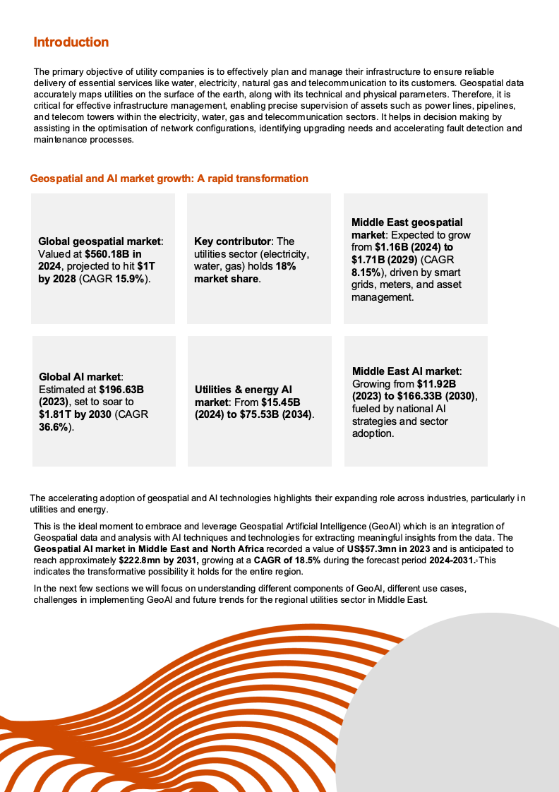
OCR:Introduction Theprimaryobjectiveofutilitycompaniesistoeffectivelyplanandmanagetheirinfrastructuretoensurereliable delivery of essential services like water, electricity,natural gas and telecommunication to its customers. Geospatial data accuratelymapsutilitiesonthesurfaceoftheearth,alongwithitstechnicalandphysicalparameters.Therefore,it is critical for effective infrastructure management, enabling precise supervision of assets such as power lines,pipelines, and telecom towers within the electricity, water, gas and telecommunication sectors. It helps in decision making by assistingintheoptimisationofnetworkconfigurations,identifyingupgradingneedsandacceleratingfault detectionand mainte nance processes. GeospatialandAlmarketgrowth:Arapidtransformation MiddleEastgeospatial Global geospatialmarket: market:Expected togrow Keycontributor:The Valuedat$560.18Bin utilitiessector(electricity from $1.16B (2024) to 2024,projected tohit $1T water,gas)holds 18% $1.71B(2029)(CAGR by 2028(CAGR 15.9%). 8.15%), driven by smart marketshare. grids,meters,andasset management. GlobalAlmarket: MiddleEastAlmarket: Growingfrom$11.92B Estimatedat$196.63B Utilities&energyAl (2023),settosoarto market:From$15.45B (2023)to$166.33B(2030) (2024)to$75.53B(2034) fueled bynational Al $1.81Tby2030(CAGR 36.6%). strategies and sector adoption. The accelerating adoption of geospatial and Al technologieshighlights their expanding role across industries,particularlyin utilities and energy. This is theideal moment to embrace and leverage Geospatial Artificial Intelligence(GeoAl) which is an integration of Geospatial data and analysis with Altechniques and technologiesfor extracting meaningful insights from the data.The GeospatialAlmarketinMiddleEastandNorthAfricarecordedavalueofUS$57.3mnin2023andisanticipatedto reachapproximately$222.8mnby2031,growingataCAGRof18.5%duringtheforecastperiod2024-2031.This indicates the transformative possibility it holds for the entire re gion. In the nextfewsectionswewill focus onunderstandingdifferent componentsofGeoAl,different usecases challengesinimplementingGeoAlandfuturetrendsfortheregionalutilitiessectorinMiddleEast.

OCR:02 Convergence of geospatial analytics with AI

OCR:Leveraging GeoAI: AStrategicApproachfor UtilityCompanies pwc www.pwc.com/me

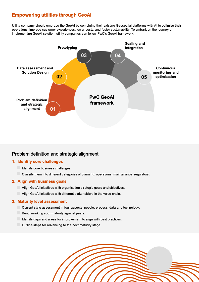
OCR:EmpoweringutilitiesthroughGeoAl Utility company should embrace the GeoAl by combining their existing Geospatial platformswith Al to optimise their operations,improve customerexperiences,lower costs,and fostersustainability.To embark on the joumey of implementingGeoAlsolution,utilitycompaniescanfollowPwC'sGeoAl framework: Scaling and Prototyping integration 03 04 Data assessment and Continuous Solution Design monitoringand 02 05 optimisation PwCGeoAl Problem definition andstrategic framework alignment 01 Problemdefinitionandstrategicalignment 1.Identifycorechallenges 1 Identify core business challenges. Classify them into different categories of planning,operations,maintenance,regulatory. 2.Align withbusinessgoals AlignGeoAlinitiativeswithorganisationstrategicgoals andobjectives Align GeoAlinitiativeswith different stakeholders in the value chain. 3.Maturitylevelassessment Current state assessment in four aspects:people,process,data and technology. 口 Benchmarkingyourmaturityagainstpeers. Identify gaps andareasforimprovement to align withbestpractices. Outinestepsfor advancing tothenextmaturity stage.

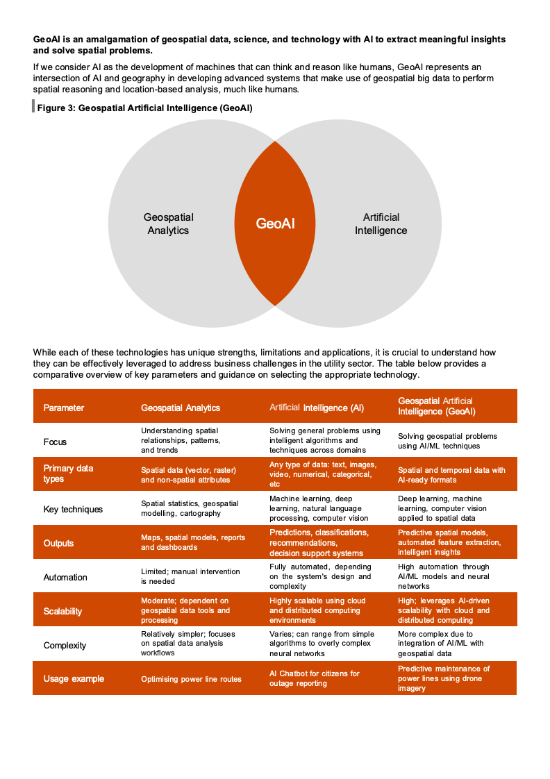
OCR:GeoAl is an amalgamation of geospatial data, science, and technology with Alto extract meaningful insights andsolvespatialproblems. If we consider Al as the development of machines that can think and reason like humans, GeoAl represents an intersection of Al and geography in developing advanced systems that make use of geospatial big data to perform spatialreasoningandlocation-basedanalysis,muchlikehumans. Figure 3:Geospatial Artificial Intelligence(GeoAl) Geospatial GeoAl Artificial Analytics Intelligence While each of these technologies hasunique strengths,limitations and applications,it is crucial tounderstand how they can be effectively leveraged to address business challenges in the utility sector.The table below providesa comparative overview of key parameters and guidance on selecting the appropriate technology. Parameter Geospatial Analytics Artificial Intelligence (Al) GeospatialArtificial Intelligence(GeoAI) Understanding spatial Solving general problems using Focus relationships, pattems, inteligent algorithms and Solving geospatial problems and trends techniques across domains using Al/ML techniques Primarydata Spatial data (vector, raster) Any type ofdata:text,images video,numerical,categorical, Spatial and temporal datawith types and non-spatial attributes Al-ready formats etc Spatial statistics, geospatial Machine learning, deep Deep le arning, machine Key techniques modeling, cartography le arning, natural language learning, computer vision processing, computer vision applled to spatial data Maps,spatial models,reports Predictions,classifications, Predictive spatial models, Outputs and dashboards recommendations, automated feature extraction decision support systems intelligent insights Limited; manual intervention Fully automated, depending High automation through Automation is needed on the system's design and AI/ML models and neural complexity networks Moderate; dependent on and distributed computing Highly scalable using cloud High; leverages Al-driven Scalabity geospatial data tools and scalabiity with cloud and processing environments distributed computing Relatively simpler; focuses Varies; can range from simple More complex due to Complexity on spatial data analysis algorithms to overly complex integration of AI/ML with workflows neural networks geospatial data Al Chatbot for citizens for Predictive maintenance of Usage example Optimisingpowerlineroutes power linesusing drone outage reporting imagery

OCR:GeoAlusecasesintheutilitysector Theproliferation of GeoAl inMiddleEast for theutility sectorhasbeenprimarilydriven byregion'surgent requirementsfor sustainable development, efficient re source management and technological modernisation. GeoAlis increasinglyrecognisedaskeyenablerinaddressingcriticalchallengesacrossutilitysectorswhilealigningwith regionalaspirationsforsustainableeconomiesandsmartcities FollowingaresomeoftheapplicationsofGeoAlintheutilitysector: Use cases Utility sectors Technology components Benefits Predictive maintenance Electricity,water,gas, Drones, ML, spatial analytics Reduced downtime,cost savings and Fault detection telecommunication assetfespanextensionextension Load forecasting and Electicity Smart grid,smartmeter, Demand prediction,energy demand response geostatistics, ML efficiency.peak loadmanagement Energy distribution Electricity Smart gridsmartmeteretwork Gridreiabitynrgyss optimisation planning. ML reduction, optimised supply Emergency response and damage Electricity,water,gas, detection,network trace Satellite imagerydrone,hange Fasterrestoration,real-tme telecommunication insights,reduced serviceimpact assessment Leak detection and Water oT,stellite,dronepressure Water/gas loss reduction,cost prevention sensors,spatial analyss savings, risk mitigation Route optimisation for Water Raster analytics,network planning. Cost-effective planning. new pipelines vector analytics environmental sustainability Asset monitoring using Electricity, water,gas, loT, remote sensing,ML Real-time insights, proactive digital twin telecommunication geospatial analytics maintenance, operational efficiency Water demand Water Watermeters,geospatial, Resource optimisation,waste forecasting geostatistical analytics reduction,suplyreliabity Non-revenue water Water meters, pressure sensors, Water network modelling. drone, spatial Revenue increase, water loss management analysis reduction, conservation Gas leak detection and Satellite and drone imagery,loT Safety enhancement, monitoring Gas sensors, ML, location analytics environmental protection, regulatory compliance Security and intrusion Video analytics, drone imagery. Infrastructure protection, detection Gas thermal imagery, ML, location regulatory compliance, operational analytics safety 5G network planning Network planner, geospatial Accelerates rollout, reduces Telecommunication analytics deployment costs, and ensures optimal coverage and connectivity Telecom database,Al, location Enhances security by preventing SIM card fraud detection Telecommunication analytics revenue lossand ensuring customer trust. Network traffic Telecommunication Network traffic database, ML, Prevents congestion,improves optimisation geospatial analytics service quality. and optimises bandwidth usage. Route optimisation for Route optimisation, Geospatial Reduces travel time and costs, field teams Telecommunication analytics, field apps data increases efficiency, and improves service delivery. Targeted marketing Telecommunication Customer network data,marketing Improves customer engagement, database increases revenue,and enhances marketing ROI Coverage gap analysis Network coverage and tower data Guides infrastructure expansion to Telecommunicatior geospatial analytics maximise user reach and minimise service gaps.

OCR:Casestudy:DetectingbrokeninsulatorsonpowerlinesusingGeoAl Electric transmission and distribution companiesmanage power linesthat usually span acrosslarge areas,usually thousands ofkilometers.Itis oftena dauntingtaskfor themaintenanceteamtoidentifymanuallybroken insulators byvisual inspection.Withtheuseofdronesthatcaptureimagesofthepowerlines,thelaborioustaskofvisual inspectionis completed.Thefigurebelowshowsaworkflow of using GeoAl tools toautomate theprocess of identifyinglocationsofthebrokeninsulatorwithevidence 01 02 03 04 05 ...06 Drone Geotagged Deep Output Focused Asset repair Capture images Learning on Map Maintenance complete Drene Geotagged images ofhe rar smbsiot Deep Learning mo del is used te The output ef the Mhe Broken Insulatoe lines are sb tored i Setectbroken In the first step the drone captures thousands of images of the power lines.Drones can reach and cover areas of transmissionlineswhicharenotaccessiblebyroadwaysforthemaintenance team. In the secondstep,thousandsofgeotagged images arestoredin thegeospatial databasewith locational information.Theusercanclickonanylocationon themapandviewtheimagesof thepowerlinesat that location Thishelps toovercome thechallengeofmanuallyviewing allimagesand accuratelyidentifybrokeninsulators. Inthethirdstep,deepleamingalgorithmswhicharetrainedonimagesofbrokeninsulators,flashed insulatorsand similar scenarios can detect the anomalyfrom thousandsofimages in few minutes, thus saving huge time,efforts andcostwhilebeingaccurate. Inthefourthstep,deepleamingalgorithmshighlightbrokeninsulatorswithdifferentcoloursbyplotting themonmapfor easy identification. The user can click on the map and verify the image of the broken insulators. In thefinal step,the maplocationswithphotos aresent to themaintenancefield crew on theirmobile phones.This hot onlyenables themto accuratelyreach thelocationofrepairbut alsoensures that theycarryappropriate toolsand replacementdevicesforcompletethejob Thisworkflowhelpsthepowerutilitiesteamtoaccuratelyidentifyexact locationsof thebrokeninsulatorsfor focused maintenance which savestime,effort and costs. FollowingaresomeofthesuccessstoriesdemonstratinghowdifferentutilitycompanieshaveimplementedGeoAl One of the major gas network operators in Europe used a combination of optical and radar satellite imagery for monitoring over 160km of high-pressure gas pipeline, which is routed through forests, fields as well as through built- upareas.VariousGeoAl toolswere employedfortimeseriesanalysis,change detectionand otherspatial analyses revealing ground deformations in pipeline areas. These deformations were classified into categories ranging from greater than 2cm/year to less than10 cm/year. Vegetation exposure to pipelines were classified from 3m to less than<10m based on theproximity of thevegetation to the pipelines.The use of GeoAl tools saved them operationmaintenance cost,time and provided them insights on their pipeline which were suspectable to risk by ground deformation and vegetation in timelymanner.They were able to take correctiveactionson identifiedfocused areas.

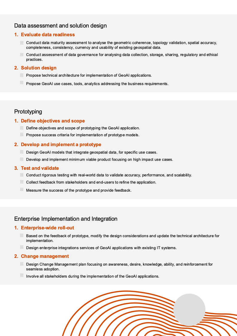
OCR:Dataassessmentandsolutiondesign 1.Evaluatedatareadiness Conduct data maturity assessment to analyse the geometric coherence,topology validation,spatial accuracy. completeness,consistency,currencyand usabilityof existinggeospatial data Conductassessmentof data govemanceforanalysing datacollection,storage,sharing,regulatory and ethica practices. 2.Solution design ProposetechnicalarchitectureforimplementationofGeoAlapplications Propose GeoAluse cases,tools,analytics addressing the businessrequirements. Prototyping 1.Define objectivesand scope DefineobjectivesandscopeofprototypingtheGeoAlapplication Propose successcriteriaforimplementation of prototypemodels 2.Developandimplementaprototype Design GeoAl models that integrate geospatial data,for specific use cases Developand implementminimumviableproductfocusing onhighimpactusecases 3.Testandvalidate Conduct rigorous testingwith real-world data tovalidate accuracy.performance,and scalability 0 Collect feedback from stakeholders and end-users torefine the application. Measure the successof theprototypeandprovide feedback EnterpriseImplementationandIntegration 1.Enterprise-wideroll-out Based on the feedback of prototype,modify the design considerations and update the technical architecture for implementation. 营 Design enterpriseintegrations services of GeoAl applications with existing IT systems. 2.Changemanagement ? Design Change Management planfocusing on awareness,desire,knowledge,ability,and reinforcement for seamlessadoption. Involve all stakeholders during the implementation of the GeoAl applications.

OCR:05InterpretabilityofAlmodels Complexity:AdvancedGeoAlmodelsareusuallybasedondeepleaming andsometimesit isdifficult to explain their decisionsmaking themact like“blackbox" ·Accountability:Lackof interpretabilitycanlead tooperationalrisks andreduced trust among stakeholders, especially in safety-critical applications. Hence it is important to use Employing Explainable Al (XAl) and using interpretable models,when possible,to address these concens 06 Ethicallmplications 2 . Bias:The training sets used in Al may contain diferent types of biaseslike geographical,selection,coverage, reporting, algorithmic, etc.It is important to consider localisation aspects and other relevant aspects for targeted implementationwhenconsidering trainingdatasets ·Job replacement: Automation of survey, field inspections may result in workforce reduction which is likely to raise concerns among the workforces. ·Fairne ss: It is important to distribute the benefits derived from Al derived insights e.g. uninterrupted power supply in rural and urban areas remains a challenge.

OCR:04 GeoAI use cases in utility sector

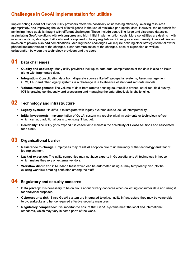
OCR:ChallengesinGeoAlimplementationforutilities ImplementingGeoAlsolutionforutilityprovidersoffersthepossibilityofincreasingefficiency,availingresources appropriately,and improving the level of intelligence in the use of available geo-spatial data.However, the approach for achievingthesegoalsisfraughtwithdifferentchallenges.Theseincludecontrollinglargeanddisperseddatasets assimilating GeoAl solutionswith existing ones and highinitial implementation costs.More so,utilitiesare dealing with internal conflicts, shortage of Al skills and is exposed toheavy regulations. Other grey areas, namely Al modelbias and invasion ofprivacy alsoaddcomplications.Meeting thesechallengeswill require definingclearstrategiesthat allowfor phased implementation of the changes, clear communication of the changes, ease of expansion as well as collaboration between the technology providers and the users 01Datachallenges Quality and accuracy: Many utility providers lack up-to-date data; completeness of the data is also an issue alongwithfragmenteddata. Integration:ConsolidatingdatafromdisparatesourceslikeloT,geospatial systems,Assetmanagement CRM, ERP and other legacy systems is a challenge due to absence of standardised data models. Volumemanagement:Thevolume of datafromremotesensing sourceslike drones,satellites,field survey, IOT is growing continuously and processing and managing the data effectively is challenging 02Technologyand infrastructure ·Legacy system: It is difficult to integrate with legacy systems due to lack of interoperability ·Initial investments: Implementation of GeoAl systemmy require initial investments or technology refresh whichcanaddadditionalcoststoexistingITbudget Scalability: The utility grids expand it is essential to maintain the scalability of GeoAl solutions and associated tech stack. 03 3Organisationalbarrier ·Resistance tochange:Employeesmayresist Aladoption due tounfamiliarityof thetechnology and fearof job replacement. ·Lack of expertise:The utility companiesmaynot have experts in Geospatial and Al technology in house which makes they rely on extemal vendors. Workflowdisruptions:MundanetaskswhichcanbeautomatedusingAlmaytemporarilydisruptsthe existing workflow creating confusion among the staff. 04 Regulatory and security concerns Data privacy:It isnecessary tobecautious about privacy concerns when collecting consumerdata and using it for analytical purposes Cybersecurityrisk:SinceGeoAl systemareintegrated tocriticalutilityinfrastructuretheymaybevulnerable tocyberattacksandhencerequiredeffectivesecuritymeasures. Regulatorycompliance:It isimportant toensure thatGeoAlsystemsmeet thelocal andinternational standards,which mayvaryinsomepartsof theworld

OCR:05 Challenges in GeoAI Implementation for utilities 12.75GHz 97% rahers BetaCane 750 Seet 52618 1/72

OCR:03 Components of GeoAI for the utility sector

OCR:01 Introduction

OCR:06 Empowering utilities through GeoAI

OCR:Geospatial analytics gains significant power when enhanced by Al-driven capabilities,such as object detection from imagery,automation, scalability for large datasets,improved accuracy,fasterprocessing and immersive technology GeoAl combines predictive,prescriptive insights with geospatial data from drones, satellite imagery and helps to solve the problem in spatial context. It also helps to automate geospatial analytics to make them autonomous and work with minimum human supervision.GeoAl brings the geographic context to solvereal world problems using multiple Al techniques object detection, spatial optimisation, natural language processing, integration with multiple data sources, etc. GeoAl applications span across sectors such as urban planning (smart city development), utilities (pipeline monitoring), agriculture (precision farming), transportation (traffic management), environmental conservation (climate change modelling),andpublichealth(epidemic tracking),enabling data-driven decision-making andenhanced operational efficiency.However,the focus of this paper will be applications of GeoAlfor utility sector, including electricity,water, gas andtelecommunication.

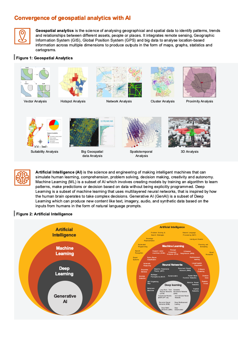
OCR:ConvergenceofgeospatialanalyticswithAl Geospatial analyticsisthescienceofanalysinggeographicalandspatialdatatoidentifypattems,trends and relationships between different assets,people or places.It integrates remote sensing, Geographic Information System (GIS),Global Position System(GPS)and big data to analyselocation-based information across multiple dimensions to produce outputs in the form of maps, graphs, statistics and cartograms. Figure 1:Geospatial Analytics Vector Analysis Hotspot Analysis Network Analysis Cluster Analysis Proximity Analysis Suitability Analysis Big Geospatial Spatiotemporal 3D Analysis data Analysis Analysis Artificial Intelligence (Ai) is the science and engineering of making intelligent machines that can simulate human leaming,comprehension,problem solving, decision making, creativity and autonomy. Machine Leaming (ML) is a subset of Al which involves creating models by training an algorithm to learn patterns, make predictions or decision based on data without being explicitly programmed. Deep Leaming is a subset ofmachinelearning that usesmultilayeredneuralnetworks,that is inspiredbyhow thehuman brain operates to take complex decisions.Generative Al(GenAl) is a subset of Deep Leaming which can produce new content like text, imagery, audio, and synthetic data based on the inputsfromhumans intheform ofnatural languageprompts. Figure 2:Artificial Intelligence Artificial Arificlal lIntellgence Intelligence Pian sea Piod Lega gi raig s Roi Machine Aetee Machine Leaming Leaming Segt S A Wong bo Nea be Deep Ae Neural Networks Darnds Mrg An Leaming Dore Deep leaming Generative PORTOPT el a AI ewretPeue Lure /CN

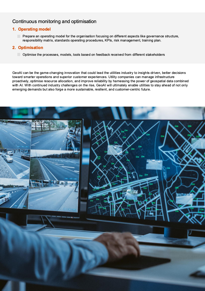
OCR:Continuousmonitoringandoptimisation 1.Operatingmodel ? Prepare anoperatingmodel for theorganisationfocusingondifferentaspectslikegovernancestructure, responsibilitymatrix,standardsoperating procedures,KPls,risk management,training plan. 2.Optimisation UOptimise the processes, models, tools based on feedback received from different stakeholders GeoAl can be the game-changing innovation that could lead the utilities industry to insights-driven,better decisions towardsmarteroperationsandsuperior customerexperiences.Utility companiescan manage infrastructure proactively,optimiseresource allocation, and improvereliability byhamessing thepower of geospatial data combined with Al.With continued industry challenges on the rise,GeoAl will ultimately enable utilities to stay ahead of not only emergingdemandsbutalsoforgeamoresustainable,resilient,andcustomer-centricfuture.

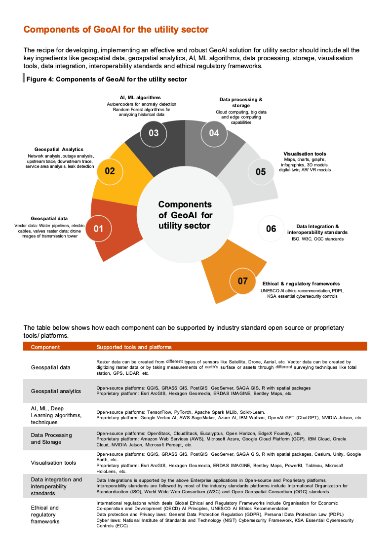
OCR:ComponentsofGeoAlfortheutilitysector Therecipe for developing,implementing an effective androbust GeoAl solution for utility sector should include all the key ingredients like geospatial data, geospatial analytics,Al, ML algorithms, data processing, storage, visualisation tools,dataintegration,interoperabilitystandardsandethicalregulatoryframeworks. Figure 4:Componentsof GeoAl for theutility sector Al, ML algorithms Aufoencoders for anomaly detection Data processing & Random Forest algorithms for storage analyzing historical data and edge computing capabilites 03 04 Geospatial Analytics Netvork analysis, outage analysis, Visualisation tools Maps, charts, gmphs, leakdetecbor 02 digital win, AR/ VR models infographics,3D models, 05 Components Geospatial data ofGeoAlfor Vector data: Water pipeines, electri 01 utilitysector 06 Data Integration & cables, valves raster data: dione images of transmission tower Interoperability standards ISO, W3C, OGC standards Ethical ®ulatory frameworks UNESCO A ethics recomm ndation, PDPL KSA essential cybersecurity controls The table below shows how each component can be supported by industry standard open source or proprietary tools/ platforms. Component Supported tools andplatforms Geospatial data Raster data can be created from different types of sensors like Satelite, Drone, Aerial,etcVector data can be created by digitizing raster data or by taking measurements of earth's surface or assets through diferent surveying techniques like total station, GPS, LiDAR, etc. Geospatial analytics Open-source platforms: QGIS, GRASS GIS,PostGIS Geo Server, SAGA GIS,R with spatial packages Proprietary platform: Esri ArcGIS, Hexa gon Geomedia, ERDAS IMA GINE, Bentley Maps, etc. AI, ML, Deep Learning algorithms, Open-source platforms:TensorFlow, PyTorch,Apache Spark MLlib, Scikit-Lean. techniques Proprietary platform: Google Vertex Al, AWS Sage Maker, Azure Al, IBM Watson, OpenAI GPT (ChatGPT), NVIDIA Jetson, etc. Data Processing Open-source platforms OpenStack,CloudStack EucalyptusOpen Horizon,EdgeXFoundry,etc and Storage Proprietary platform: Amazon Web Services (AWS), Micarosot Azure, Google Cloud Platform (GCP), IBM Cloud, Oracle Cloud, NVIDIA Jetson, Microsoft Percept, etc. Visualisation tools Proprietary platfom: Esri ArcGIS, Hexagon Geomedia, ERDAS IMAGINE, Bentiey Maps, PowerBl, Tableau, Microsot Earth, etc. HoloLens, etc. Data integration and Data Integrations is supported by the above Enterprise applications in Open-source and Proprietary plaforms interoperability Interoperabilty standards are followed by most of the industry standards platforms include Intemational Organization for standards Standardization (ISO), World Wide Web Consortium (W3C) and Open Geospatial Consortium (OG C) standards Ethical and Intemational regulafions which deals Global Ethical and Regulatory Frameworks include Organisation for Economic Co-operation and Development (OECD) AI Principles, UNES CO Al Ethics Recommendation regulatory Data protection and Privacy laws: General Data Protection Regulation (GDPR), Personal Data Protection Law (PDPL) frameworks Cyber laws: National Institute of Standards and Technology (NIST) Cyberse curity Framework, KSA Essential Cybersecurity Controls (ECC)

OCR:A leading telecommunication in Middle East faced challenges in optimising their network performance which included identifying weak signal zones,managing network traffic duringpeak events like concerts or sports matches,planning efficient5Gdeploymentacrossdiverseurbanandrurallandscapes.Thecompanyimplemented differentGeoAluse cases like Call routing optimisation which deployed ML algorithms to direct calls through the least congested routes, ensuring uninterrupted communication. Real time spatial analytics were used during sports events, music concerts to monitoruserdensityandadjustnetworkresourcesinreal time tomaintainoptimalperformance Bydeploying differentGeoAltoolsthecompany sawa 25%reduction in deploymentcosts throughbetternetwork planning.They also observed a20%increase inmobile internet speedswhichresulted inimproving services and resulted in user satisfaction.The company also observed faster response times to outages and disruptions,reducing servicedowntime.